
Maps
Nysse transit map
The printed version of Nysse’s transit map can be found at bus and tram stop shelters and in the Passenger Guide brochure, which is available free of charge from customer service. The Nysse service area has been condensed on the map to a size suitable for printed materials, so the map does not represent the actual geographical locations, shapes, proportions, or distances of places.
You can explore seasonal route networks in more detail using the map service, which works best on larger screens.
Main stops in the center of Tampere
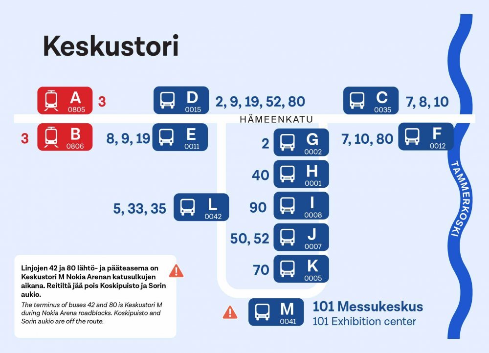
The Keskustori stops at Tampere central square are located in the heart of the city, west side of Hämeensilta bridge.
Tram stops
Tram stops are located on Hämeenkatu, next to Tampere Town Hall and the Market Hall. The links will take you to the Journey Planner, where you can check the lines and timetables for the stop.
Keskustori A 0805 Keskustori B 0806
Bus stops
Bus stops are located along Hämeenkatu and in the terminal area. The links will take you to the Journey Planner, where you can check the lines and timetables for the stop.
Keskustori C 0035 Keskustori D 0015 Keskustori E 0011 Keskustori F 0012 Keskustori G 0002 Keskustori H 0001 Keskustori I 0008 Keskustori J 0007 Keskustori K 0005 Keskustori L 0042 Keskustori M 0041
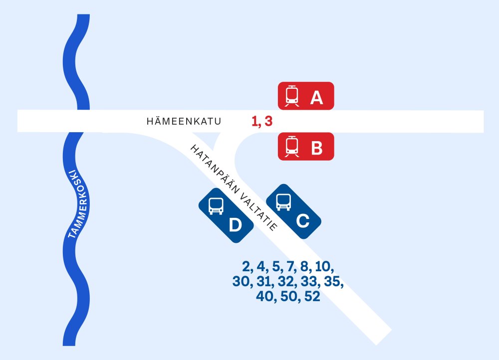
The Koskipuisto stops are located in the heart of the city, east side of Hämeensilta bridge.
Tram stops
Tram stops are located on Hämeenkatu, east side of Hatanpään valtatie intersection. The links will take you to the Journey Planner, where you can check the lines and timetables for the stop.
Koskipuisto A 0807 Koskipuisto B 0808
Bus stops
Bus stops are located in Western edge of Hatanpään valtatie. The links will take you to the Journey Planner, where you can check the lines and timetables for the stop.
Tram stops
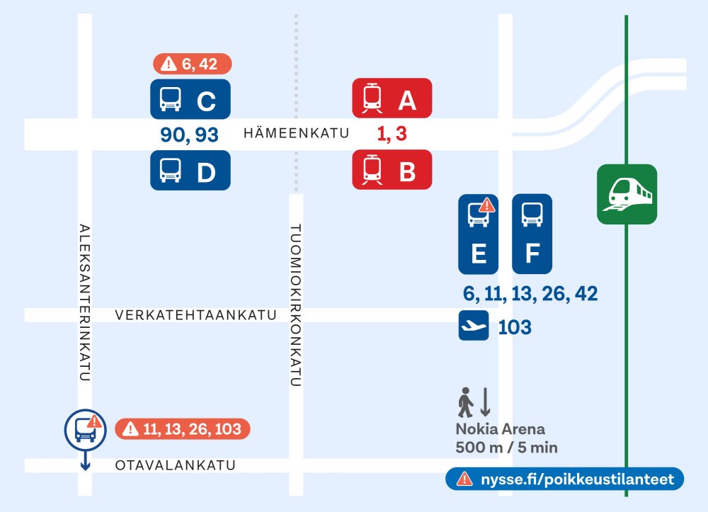
The tram stops are located on Hämeenkatu, in the block between Rautatienkatu and Tuomiokirkonkatu. The links will take you to the Journey Planner, where you can check the lines and timetables for the stop.
Rautatieasema A 0809 Rautatieasema B 0810
Bus stops
The bus stops C and D are located on Hämeenkatu, in the block between Aleksanterinkatu and Tuomiokirkonkatu. Stops E and F are located on Rautatienkatu, in the block between Hämeenkatu and Verkatehtaankatu. The links will take you to the Journey Planner, where you can check the lines and timetables for the stop.
Rautatieasema C 0505 Rautatieasema D 0504 Rautatieasema E 0506 Rautatieasema F 0526
Stop E not in use during detour routes for Nokia Arena events.
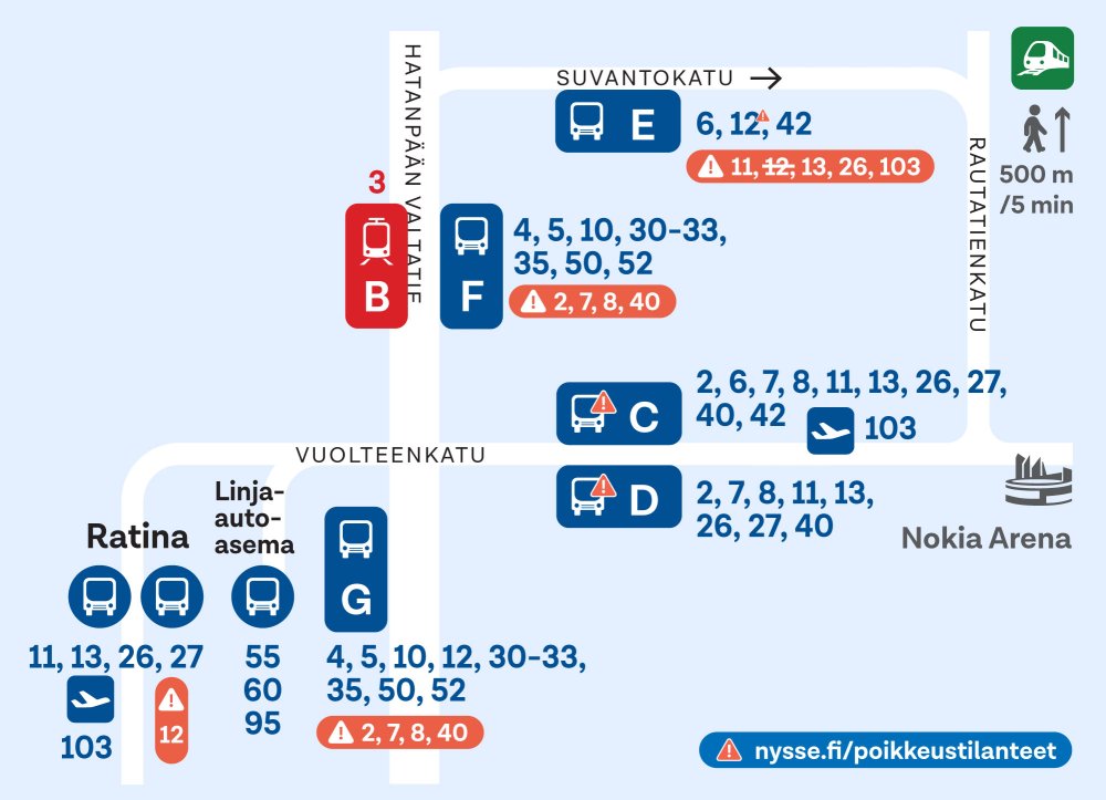
Sorin aukio is located in the eastern part of Tampere city centre. Nearby are major event venues such as Nokia Arena and Ratina Stadium, as well as the city's large shopping centres and bus station.
Tram stop
The tram stop is located on Hatanpään valtatie, in the block between Suvantokatu and Vuolteenkatu. The link will take you to the Journey Planner, where you can check the lines and timetables for the stop.
Bus stops
The bus stops C and D are located on Vuolteenkatu, in the block between Hatanpään valtatie and Rautatienkatu. Stop E is on Suvantokatu and stop F on Hatanpään valtatie, in the block between Suvantokatu and Vuolteenkatu.
Sorin aukio C 0569 Sorin aukio D 0570 Sorin aukio E 0580 Sorin aukio F 0523
Find Your Way with the Journey Planner
The Journey Planner provides up-to-date timetables, route information for lines, and details about service disruptions.
It guides you from your starting point to your destination, including walking directions.