


 Children 0-16
 Youth 17-24
 Students
 Accessibility
 Luggage
 Animals
 Disruptions
 Tram
Tram
Tampere
Modern mobility in a growing city
Tampere is the heart of the Nysse service area — it serves as a hub connecting all municipalities in the Nysse region. The public transportation network consists of an extensive bus route system, a modern tram system, and regional train connections. Trams provide fast connections from Lentävänniemi to Kauppi and Hervanta, and buses provide connections to all city neighborhoods.
Public transportation runs at frequent intervals, especially on trunk routes 1–10, and traveling is easy thanks to a unified, regional fare system.
There are several park-and-ride facilities in Tampere where you can leave your car or bike and continue your journey on a Nysse. In addition, city bikes are available from spring through autumn in various parts of the city.
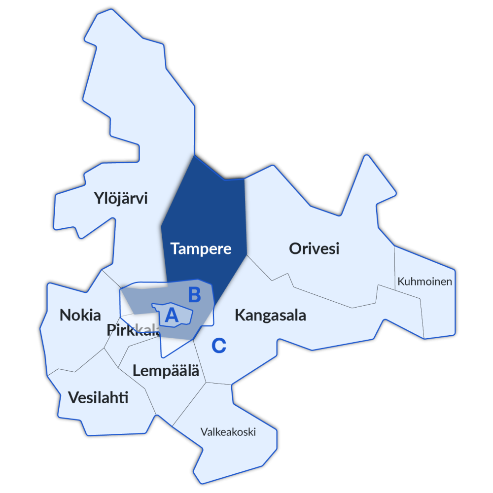
Tampere's Service Level targets 2026-2030
While defining service levels, we found that there are neighborhoods where the current level of public transportation service falls short of the set targets. On the other hand, there are also several areas where the service level is excessive in relation to the number of residents and jobs in the area.
Regional service level categories are available in print on this page. They can also be viewed on the map service.
 Explore the service levels on the map
The map service lets you see the level of public transportation service in different areas at a glance.
The colors of the public transportation routes indicate where the level of service changes and how service is distributed across different areas. The map is particularly useful for planning routes, comparing areas, and understanding the overall picture of public transportation.
The map service works best on larger screens, but it can also be used on mobile devices.
Service levels in Tampere
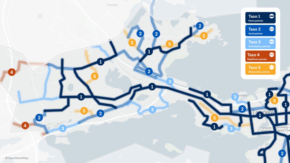
1. Best service
- Hämeenkatu
- Hämeenpuisto
- Pyynikinrinne–Santalahti ja Pispala
- Pyynikki (western ends)–Tahmela
- Epilä–Tohloppi–Tesoma–Haukiluoma
- Käräjätörmä, Tesomajärvi, Kalkunvuori, Ylä-Rahola
- Lielahti–Niemenranta–Lentävänniemi.
2. Good service
- Finlayson–Amuri
- Lielahti–Hiedanranta
- Lintulampi–Ryydynpohja
- Pohtola
- Lentävänniemi north side (from Halkoniemi northwards)
- Kaarila–Ala-Rahola–Villilä
- Kalkku
- Myllypuronkatu between Haukiluoma–Tohloppi
3. Moderate service
- Särkänniemi
- Eastern ends of Pyynikki
- Kaarila, Ranta-Kaarila
- Vaitinaro
- Nokiantie: Mustavuori–Villilänsaari
- Ikuri–Myllypuro.
4. Limited service
- The western section of Kalkku causeway
- North end of Myllypuro.
5. Focused service
- Pispalanharju
- Reuharinniemi
- Korvenkatu (Rahola)
- Lielahdenkatu (Niemi)
- Teivaalantie (Ryydynpohja)
- Tohloppi–Lamminpää
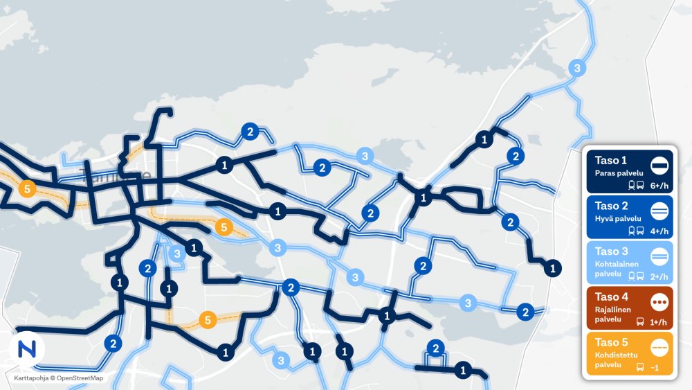
1. Best service
- Hämeenkatu
- Ratina
- University (city centre campus)
- Kyttälä
- Tulli
- Jussinkylä (partially)
- Kaleva
- Kalevanrinne
- Kalevanharju
- Kaupin kampus
- Kissanmaa
- Hakametsä
- Ristinarkku
- Tampella
- Tammela
- Lapinniemi
- Lappi
- Uusikylä
- Linnainmaa
- Atala (partially)
- Holvasti (partially)
2. Good service
- Petsamo
- Kauppi
- Ruotula
- Takahuhti
- Huikas
- Pappila
- Ristinarkku
- Leinola (partially)
- Hankkio
- Haihara
- Vehmainen (partially)
- Holvasti (partially)
- Tasanne (partially)
- Atala (partially)
3. Moderate service
- Kalevanharju
- Vuohenoja
- Aakkula
- Messukylä
- Leinola (partially)
- Vehmainen (partially)
- Atala (partially)
- Ojala
- Olkahinen (Aitolahdentie)
- Ruotula, Takahuhti, Pappila (Teiskontie)
4. Limited service
No applicable areas
5. Focused service
- Jussinkylä
- Kalevanharju
- Järvensivu (Järvensivuntie)
- Jyväskyläntie (Kaupinlaakso, Niihama, Olkahinen)
1. Best service
- Hatanpää
- Rantaperkiö
- Härmälä-Härmälänranta (Nuolialantie)
- Lakalaiva (partially)
- Peltolammi (Lempääläntie between Pähkinämäenkatu–Säästäjänkatu)
2. Good service
- Sarankulmankatu (Rantaperkiö, Härmälä)
- Multisilta (north of Multivuori)
3. Moderate service
- Rautaharkko
- Lakalaiva
- Valtatie 3 (Lakalaiva, Peltolammi, Multisilta)
- Multisilta (partially)
- Sarankulma
4. Limited service
No applicable areas
5. Focused service
- Rukkamäentie (Peltolammi, Sarankulma)
1. Best service
- Nekalantie (Viinikka, Nekala)
- Vihioja
- Jokipohja (Kuoppamäentie)
- Hallilantie between Laulunmaankatu – Veisunkatu (Muotiala, Korkinmäki, Veisu)
- Veisunkatu (Koivistonkylä, Veisu)
- Koivistonkylä (Nirvankatu)
- Taatala
- Vuores (partially)
- Hallila (partially)
- Turtola (Turtolankatu between Santaharjuntie – Turtolantahnua)
- Lukonmäki
- Viiala (Vasaratie)
- Kaukajärvi
- Juvankatu between Annalankatu – Saarenmaantie (Annala)
- Insinöörinkatu between Kanjoninkatu – Näyttämönkatu (Hervanta)
- Hervannan valtaväylä between Vaajakatu – Näyttämönkatu (Hervanta)
- Tieteenkatu (Northeast Hervanta)
- Helpolamminkatu between Tieteenkatu – Turtolankatu (Northeast Hervanta)
- Opiskelijankatu between Insinöörinkatu – Ruovedenkatu (Northwest Hervanta)
- Teekkarinkatu (Hervanta)
- Ahvenisjärventie between Teekkarinkatu – Opinpolku (Northwest Hervanta)
- Arkkitehdinkatu (Southwest Hervanta)
2. Good service
- Nekalantie (Jokipohja, Muotiala)
- Automiehenkatu between Valtatie 3 – Aunankorvenkatu (Lahdesjärvi)
- Vuores (partially)
- Korkinmäki (partially)
- Turtola (Sotilaankatu)
- Haihara
- Hervantajärvi (partially)
- Annala (Annalankatu – Hikivuorenkatu – Ojavainionkatu, Juvankadun pohjoispuolella)
- Hermiankatu (Southeast Hervanta)
- Opiskelijankatu between Ahvenisjärventie – Ruovedenkatu (Northwest Hervanta)
- Ahvenisjärventie between Opinpolku – Opiskelijankatu (Northwest Hervanta)
- Ruovedenkatu (Northwest Hervanta)
- Kanjoninkuja (Northwest Hervanta)
3. Moderate service
- Ahlmanintie (Viinikka, Nekala)
- Viinikka
- Nirva
- Lahdesjärvi
- Ruskontie/Ruskonkehä (Vuores, Hervanta, Hervantajärvi)
- Rusko
- Hallila (Lehtimetsänkatu)
- Korkinmäki (partially)
- Turtolankatu between Pyykkiojankatu – Vasaratie (Turtola, Lukonmäki), Northeast Hervanta
- Viiala (Messukylänkatu)
- Kaukajärvi (partially)
- Hervantajärvi (partially)
- Annala (partially)
- Ahvenisjärventie between Arkkitehdinkatu – Ruskonkehä (Southwest Hervanta)
- Kauhakorvenkatu (Rusko, Hervanta)
- Hervannantie between Ruskonkehä – Kauhakorvenkatu (Southeast Hervanta)
4. Limited service
No applicable areas
5. Focused service
- Veisu (Hallilantie)
- Taatala (Viinikankatu)
- Koivistontie until Nirvankatu (Koivistonkylä)
1. Best service
No applicable areas
2. Good service
No applicable areas
3. Moderate service
No applicable areas
4. Limited service
- Kaitavedentie between Aitolahdentie – Kiviojantie (Nurmi, Sorila)
- Kämmenniemenkatu (Kämmenniemi)
- Paavolantie between Kämmenniemenkatu – Ullakonvainio (Kämmenniemi)
5. Focused service
- Sorila (partially)
- Aitoniemi
- Kämmenniemi (partially)
- Viitapohja
- Polso
- Terälahti
- Velaatta
 Development compass
Tampere’s public transit system has undergone significant changes in the 2020s with the introduction of the tram network. The next major change will take place in 2028, when the tram line will be extended through Hatanpää and Härmälä to Partola in Pirkkala. At the same time, service on bus routes 7 and 8 will be revamped.
In Tampere, the key priorities for the development of public transportation for 2026–2030 are:
1. Neighbourhood-based planning.
We use the City district programme (in Finnish) in our route network planning.
- Areas of focus: Annala–Kaukajärvi, Multisilta–Peltolammi, Tesoma, and Hervanta.
- Monitoring areas: Härmälä, Lielahti, Linnainmaa, Lentävänniemi, Kalkku, Nekala
2. Noticing growing public transit hotspots.
- We are expanding service in areas where the tram network is not being extended.
- We are designing a functional service package as part of the Route network 2028 project.
3. Improving the operating conditions for public transportation on the street network
- We are strengthening our collaboration with land-use planning.
- We are clarifying Nysse's role in the park-and-ride service concept.
- We are improving the reliability of public transportation through targeted measures (improvements to the street network).
 More information