


 Children 0-16
 Youth 17-24
 Students
 Accessibility
 Luggage
 Animals
 Disruptions
 Tram
Tram
Central Tampere 2028
The centre is more than just Hämeenkatu
In the Route Network 2028 plan, Tampere’s city centre is viewed as a broader whole rather than merely Hämeenkatu or Keskustori. Connections will be developed to key destinations in the city centre, such as the areas around the train station and Ratina, as well as the Finlayson, Kyttälä, and Tulli neighborhoods.
The Plusbus service and the expansion of the tram network are changing the transportation landscape in the city centre, but at the same time, connections are improving from an increasing number of areas. The route renewal will increase the frequency of service, improve connections between different areas, and strengthen travel chains.
There are still direct connections to the city centre from Tampere’s largest suburbs and neighboring municipalities. At the same time, travelers from many areas will be able to reach the city centre with just one transfer.
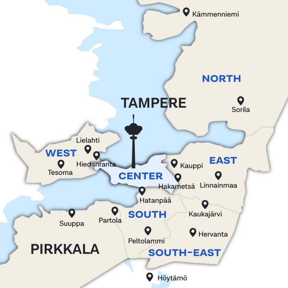
Areas in central Tampere: Amuri, Armonkallio, Finlayson, Iidesranta, Järvensivu, Kaakinmaa, Kaleva, Kalevanrinne, Käpylä, Kyttälä, Lappi, Lapinniemi, Nalkala, Onkiniemi, Osmonmäki, Petsamo, Pispala, Pyynikki, Pyynikinrinne, Ranta-Tampella, Ratina, Saukonmäki, Särkänniemi, Tahmela, Tammela, Tampella, Tulli.
Trams in the city centre
Pyhällönpuisto – Lentävänniemi – Niemenranta – Niemen kartano – Tehdas – Hiedanranta – Santalahti – Tikkutehdas –Särkänniemi – Pyynikintori – Tuulensuu – Keskustori – Koskipuisto – Rautatieasema– Tulli – Sammonaukio – Kalevan kirkko – Hippos – TAYS – Kaupin kampus – Ruotula
Travel times:
- Lentävänniemi – Hiedanranta 6 min
- Hiedanranta – Keskustori 12 min
- Keskustori – Kaupin kampus 13 min
- Kaupin kampus – Ruotula 2 min
Hervantajärvi – Etelä-Hervanta – Hervannan kampus – Hervantakeskus – Opiskelija – Hallila – Turtola – Hakametsä – Kalevanrinne – Uintikeskus – Kaleva – Sammonaukio – Tulli – Rautatieasema – Koskipuisto – Sorin aukio – Viinikanlahti – Hatanpää – Arboretum – Rantaperkiö – Härmälä – Härmälänranta – Partola
Travel times:
- Hervantajärvi – Hervantakeskus 4 min
- Hervantakeskus – Hakametsä 10 min
- Hakametsä – Sorin aukio 13 min
- Sorin aukio – Partola 13 min
Trunk routes in the city centre
Rauhaniemi – Käpylä – Lappi – Osmonmäki – Tammela – Tulli – Tampere-talo – Yliopisto – Sorin aukio – Koskipuisto – Keskustori
Rauhaniementie – Naistenlahdenkatu – Pohjolankatu - Tammelan puistokatu - Yliopistonkatu - Kalevantie - Vuolteenkatu – Hatanpään valtatie - Hämeenkatu - Keskustori
Itineraries and route numbers are preliminary and may change during the further planning of the 2028 Route Network. Final decisions will be made as the planning process progresses in autumn 2026.
Lentävänniemi – Lielahti – Tohloppi/Lamminpää – Käräjätörmä – Tesoma – Kaarila –Epilä – Pispala – Amuri – Finlayson – Kyttälä – Rautatieasema – Sorin aukio – Ratina – Viinikka – Nekala – Jokipohja – Muotiala – Turtola – Viiala – Lukonmäki – Hervantakeskus – Länsi-Hervanta
Jänislahdenkatu - Lielahdenkatu - Paasikiventie - Myllypuronkatu - Tesoman valtatie - Nokiantie - Pispalan valtatie - Pirkankatu - Satakunnankatu - Rongankatu - Rautatienkatu - Vuolteenkatu - Tampereen valtatie - Nekalantie - Jokipohjantie - Kuoppamäentie - Nekalantie - Sotilaankatu - Turtolankatu - Hepolamminkatu - Orivedenkatu - Insinöörinkatu - Teekkarinkatu - Ahvenisjärventie
Itineraries and route numbers are preliminary and may change during the further planning of the 2028 Route Network. Final decisions will be made as the planning process progresses in autumn 2026.
Länsi-Hervanta – Opiskelija – Hervantakeskus – Etelä-Hervanta – Kotkansiipi – Mäyränmäki – Vuores – Virolainen – Aurinkorinne – Västinginmäki – Lahdesjärvi – Peltolammi – Lakalaiva – Taatala – Vihioja – Nekala –Viinikka – Sorin aukio – Koskipuisto – Keskustori
Ahvenisjärventie - Opiskelijankatu - Insinöörinkatu - Orivedenkatu - Tieteenkatu - Hervannan valtaväylä - Näyttämönkatu - Arkkitehdinkatu - Ahvenisjärventie - Ruskonkehä - Mäyränmäenkatu - Vuoreksen puistokatu - Automiehenkatu - Lempääläntie - Lahdenperänkatu - Viinikankatu - Kuokkamaantie - Ahlmanintie (- Kaartotie - Lempääläntie / Viinikankatu) - Tampereen valtatie - Hatanpään valtatie - Hämeenkatu - Keskustori
Itineraries and route numbers are preliminary and may change during the further planning of the 2028 Route Network. Final decisions will be made as the planning process progresses in autumn 2026.
Vatiala – Kiveliö - Leinola/Holvasti – Linnainmaa – Ruotula – Tays Keskussairaala – Kaleva – Sammonaukio – Sorsapuisto – Rautatieasema – Sorin aukio
Mäkirinteentie – Vällintie - Vatialantie - Holvastintie - Orimuskatu - Mäentakusenkatu - Heikkilänkatu - Teiskontie - Itsenäisyydenkatu – Rautatienkatu – Vuolteenkatu – Hatanpään valtatie – Suvantokatu
Käräjätörmä – Tesoma – Kalkku – Villilä – Rahola – Kaarila – Epilä – Pispala – Pyynikinrinne – Pyynikintori – Keskustori – Koskipuisto – Sorin aukio – Yliopisto – Kalevanharju – Kalevanrinne – Hakametsä – Uusikylä – Janka – Ristinarkku – Linnainmaa
Tesoman valtatie - Tesomankatu - Kalkunvuorenkatu - Kalkun kehätie - Ristaniitynkatu - Pitkäniemenkatu - Kalkun viertotie - Kalkun kehätie - Nokiantie - Pispalan valtatie - Pirkankatu - Hämeenkatu - Hatanpään valtatie - Vuolteenkatu - Kalevantie - Takojankatu - Sarvijaakonkatu - Rieväkatu - Sammonkatu - Sammon valtatie - Alasniitynkatu - Ristinarkuntie - Sammon valtatie - Aitolahdentie - Mäentakusenkatu
The route will be part of the plusbus service.
During diversions due to events at Nokia Arena the route will run via Kanslerinrinne and Tampereen valtatie instead of Vuolteenkatu.
Haukiluoma – Ikuri – Tesoma – Ristimäki – Mediapolis – Tohlopinranta – Epilä – Pispala – Pyynikinrinne – Pyynikintori – Keskustori – Koskipuisto – Sorin aukio – Yliopisto – Kalevanharju – Vuohenoja – Aakkula – Messukylä – Hankkio – Kaukajärvi – Annala – Kaipanen
Tyvikatu - Heinämiehentie - Karjakontie - Virontörmänkatu - Tesomankatu - Kohmankaari - Kohmankatu - Tohlopinranta - Epilänkatu - Pispalan valtatie - Pirkankatu - Hämeenkatu - Hatanpään valtatie - Vuolteenkatu - Kalevantie - Messukyläntie - Messukylänkatu - Kangasalantie - Juvankatu
The route will be part of the plusbus service.
During diversions due to events at Nokia Arena the route will run via Kanslerinrinne and Tampereen valtatie instead of Vuolteenkatu.
Särkänniemi – Hämeenpuisto – Tuulensuu – Kaakinmaa – Eteläpuisto – Ratinanranta – Ratina – Sorin aukio – Rautatieasema – Kyttälä – Vapriikki – Tampella – Ranta-Tampella – Saukonmäki – Sammonaukio – Hippos – Tays Keskussairaala – Kissanmaa – Uusikylä – Hakametsä
Laiturikatu - Paasikivenkatu - Näsijärvenkatu - Hämeenpuisto - Tampereen valtatie - Vuolteenkatu - Rautatienkatu - Rongankatu - Lapintie - Juhlatalonkatu - Tampellan esplanadi - Kekkosenkatu - Pohjolankatu - Kalevan puistotie - Teiskontie - Kissanmaankatu - Pelikatu - Hervannan valtaväylä - Rieväkatu
Itineraries and route numbers are preliminary and may change during the further planning of the 2028 Route Network. Final decisions will be made as the planning process progresses in autumn 2026.
Tahmela – Pyynikki – Kaakinmaa – Pyynikinrinne – Tuulensuu – Keskustori – Koskipuisto – Sorin aukio – Hatanpää – Taatala – Nirva – Veisu – Muotiala – Turtola – Viiala – Kaukajärvi
Tahmelankatu – Pyynikintie – Mariankatu – Pirkankatu – Hämeenkatu – Hatanpään valtatie – Hatanpäänkatu – Hatanpään puistokuja – Hatanpään valtatie – Lahdenperänkatu – Lempääläntie – Koivistontie – Nirvankatu – Veisunkatu – Hallilantie – Nekalantie – Sotilaankatu – Turtolankatu – Vasaratie – Santaharjuntie – Keskisenkatu – Haiharankatu
Itineraries and route numbers are preliminary and may change during the further planning of the 2028 Route Network. Final decisions will be made as the planning process progresses in autumn 2026.
Lentävänniemi – Niemenranta – Lielahti – Hiedanranta – Santalahti – Särkänniemi (Savilinna) – Pyynikintori – Tuulensuu (Aleksanterin kirkko/Metso) – Keskustori – Koskipuisto – Sorin aukio – Yliopisto – Tampere-talo – Sorsapuisto – Sammonaukio – Kaleva – Tays Keskussairaala – Ruotula – Tenniskeskus – Alasjärvi – Niihaman liityntäpysäköinti – Linnainmaa – Atala
Jänislahdenkatu - Lielahdenkatu - Kehyskatu - Federleynkatu - Lielahdenkatu - Enqvistinkatu - Paasikiventie - Paasikivenkatu - Sepänkatu - Pirkankatu - Hämeenkatu - Hatanpään valtatie - Vuolteenkatu - Sorinsilta - Kalevantie - Yliopistonkatu - Itsenäisyydenkatu - Teiskontie - Heikkilänkatu - Aitolahdentie - Nikinväylä
Route 20 runs at night (outside of the service hours of tram line 1) as well as during prolonged disruptions to tram service.
Itineraries and route numbers are preliminary and may change during the further planning of the 2028 Route Network. Final decisions will be made as the planning process progresses in autumn 2026.
Järvensivu - Tulli - Sorin aukio - Ratina - Ratinanranta - Eteläpuisto - Kaakinmaa - Pyynikki - Ylä-Pispala - Pispalanharju
List of roads: Järvensivuntie - Ratapihankatu - Kanslerinrinne - Kalevantie - Vuolteenkatu - Ratina - Vuolteenkatu - Tampereen valtatie - Hämeenpuisto - Satamakatu - Laiskolankuja - Palomäentie - Tahmelantie - Pispalanharju
Petsamo – Osmonmäki – Armonkallio – Kyttälä – Rautatieasema – Sorin aukio – Ratina – Viinikka – Taatala – Lakalaiva – Peltolammi – Palokallio – Multisilta
(Kasvitarhankatu - Piennarkatu -) Lusankatu - Koljontie - Kalevan puistotie - Pohjolankatu - Naistenlahdenkatu - Lapintie - Rongankatu - Rautatienkatu - Vuolteenkatu - Tampereen valtatie - Lempääläntie - Automiehenkatu - Autovarikonkatu - Eteläinen Lempääläntie - Lempääläntie - Kaartotie - Ahlmanintie - Kuokkamaantie - Viinikankatu - Lahdenperänkatu - Lempääläntie - Multiojankatu
Itineraries and route numbers are preliminary and may change during the further planning of the 2028 Route Network. Final decisions will be made as the planning process progresses in autumn 2026.
Terälahti – Maisansalo – Kämmenniemi – Kolunkylä – Vääräjärvi – Sorila – Nurmi – Niihama – Ruotula – Tays Keskussairaala – Hippos – Kaleva – Tampere-talo – Yliopisto - Sorin aukio – Linja-autoasema
Niemenkyläntie - Terälahdentie - Kuorannantie - Polsontie - Kuorannantie - Terälahdentie - Aunessalmenkatu – Kämmenniemenkatu - Kaitavedentie - Eerolansuorantie - Kaitavedentie - Valtatie 9 - Teiskontie - Itsenäisyydenkatu - Yliopistonkatu - Kalevantie - Sorinsilta - Vuolteenkatu
Some of the departures bound for Linnainmaa-Kämmenniemi will be under the name 90A via Aitolahdentie (instead of Jyväskyläntie). The departures are specifically designed to meet the needs of schoolchildren.
Regional bus routes
Pirkkala – Niemenmaa – Solja – Turri/Kyösti – Turkkirata – Vaitti – Linnakallio – Viinikka – Linja-autoasema
Suupantie - Lentoasemantie - Naistenmatkantie - Turkkirata - Teollisuustie - Jasperintie - Kurikantie - Tampereen läntinen kehätie - Valtatie 3 - Lempääläntie - Tampereen valtatie - Vuolteenkatu
Itineraries and route numbers are preliminary and may change during the further planning of the 2028 Route Network. Final decisions will be made as the planning process progresses in autumn 2026.
Kangasala – Suorama – Liuttu – Hankkio – Messukylä – Aakkula – Vuohenoja – Järvensivu – Iidesranta – Sorin aukio – Koskipuisto – Keskustori
Onnikkatie - Tampereentie – Kangasalantie – Rekiäläntie - Finnentie - Kaarina Maununtyttärentie - Kangasalantie - Messukylänkatu – Kalevantie – Iidesranta - Tampereen valtatie – Hatanpään valtatie - Hämeenkatu – Keskustori
Routes in Kangasala: 40A Pikonlinna / 40B Huutijärvi / 40C Kangasalan asema – Kangasala
- A: Pikonlinnantie – Ruutanantie – Tampereentie – Onnikkatie
- B: Lehtipuuntie - Sahalahdentie – Alatie – Herttualantie - Kuohunharjuntie – Tampereentie – Onnikkatie
- C: Asemantie – Ruutanantie - Tampereentie – Onnikkatie
Itineraries and route numbers are preliminary and may change during the further planning of the 2028 Route Network. Final decisions will be made as the planning process progresses in autumn 2026.
Kuhmoinen – Kangasala – Pohja – Kuhmalahti – Sahalahti – Mobilia – Huutijärvi – Kangasala – Suorama – Lentola – Niihama – Ruotula – Tays - Kaleva (Teiskontie) – Sorsapuisto – Tampere-talo – Yliopisto – Sorin aukio – Linja-autoasema
Toritie - Yhdystie - Nelostie - Tampereentie - Sappeentie - Rautajärventie - Pohjantie - Kuhmalahdentie - Sahalahdentie – Kisarannantie – Kisarannantie – Sahalahdentie - Alatie - Herttualantie - Kuohunharjuntie - Tampereentie - Onnikkatie - Kangasalantie - Lahdentie - Teiskontie – Itsenäisyydenkatu – Yliopistonkatu - Kalevantie - Sorinsilta – Vuolteenkatu
Lempäälä - Hakkari - Moisio - Ideapark - Kulju - Väinölä - Kukonkorpi - Ahohperä - Sääksjärvi - Multisilta - Peltolammi - Lakalaiva - Taatala - Viinikka - Ratina - Koskipuisto - Keskustori
Tampereentie - Kuljuntie - Ideaparkinkatu - Helsingintie - Kuljuntie - Yhdystie - Tampereentie - Lempääläntie - Peltolammi - Lempääläntie - Tampereen valtatie - Hatanpään valtatie - Hämeenkatu - Keskustori
52A Haurala / 52B Laasonportti – Lempäälä – Hakkari – Moisio – 52A Vanattara / 52B Ruskea-ahde – Kulju – Väinölä – Kukonkorpi – Ahonperä – Sääksjärvi – Multisilta – Palokallio – Viinikka – Ratina – Koskipuisto – Keskustori
52A Hauralantie – Viialantie - Valkeakoskentie - Puistokatu - Lemponkatu - Tampereentie - Vanattarantie - Tampereentie - Lempääläntie - Eteläinen Lempääläntie - Leppästensuonkatu - Valtatie 3 - Lempääläntie - Tampereen valtatie - Hatanpään valtatie - Hämeenkatu - Keskustori
52B Laasontie - Ahtialantie - Valkeakoskentie - Puistokatu - Lemponkatu - Tampereentie - Lempääläntie - Eteläinen Lempääläntie - Leppästensuonkatu - Valtatie 3 - Lempääläntie - Tampereen valtatie - Hatanpään valtatie - Hämeenkatu - Keskustori
Itineraries and route numbers are preliminary and may change during the further planning of the 2028 Route Network. Final decisions will be made as the planning process progresses in autumn 2026.
(Narva -) Vesilahti - Lempäälä - Hakkari - Moisio - Ideapark - Valtatie 3/9 - Sääksjärvi - Viinikka - Ratina, linja-autoasema
List of roads: (Latomaantie – Vesilahdentie – Rautialantie -) Rautialantie – Vesilahdentie – Viialantie – Tampereentie – Kuljuntie – Ideaparkinkatu – Helsingintie – Valtatie 3 – Lempääläntie - Tampereen valtatie - Hatanpään valtatie - Linja-autoasema
Valkeakoski, Linja-autoasema - Tallinmäki - Antinniemi - Matinmäki - Lotila - Juusonranta - Pispantalli - Saarioinen - Taimisto - Heiniö - Tikinmaa - Perimmäinen - Ruokolammi - Lastustenkulma - Teerentie - Hormistontie - Rautasema - Motia - Hulikankulma - Marjamäki - Ideapark - Sääksjärvi - Viinikka - Ratina, Linja-autoasema
List of roads: Mallasvedenkatu - Sääksmäentie - Ulvajankatu - Tallikatu - Lempääläntie - Tampereentie - Helsingintie - Marjamäentie - Ideaparkinkatu - Helsingintie - Valtatie 3 - Lempääläntie - Tampereen valtatie - Hatanpään valtatie - Linja-autoasema
Harjuniitty – Taka-Lauttala – Nokia – Maatiala – Hyhky - Pispala – Pyynikintori - Keskustori
List of roads: Urpolankatu – Taka-Lauttalankatu – Pinsiöntie – Rautatienkatu – Pinsiöntie – Nokian valtatie – Valtatie 12 – Pispalan valtatie – Pirkankatu – Hämeenkatu - Keskustori
Sammalisto – Tervasuo – Sotka – Kattilainen – Ketolanmäki – Tyrkkölä – Vihola – Pirkkalaistori - Nokia – Kennonnokka – Valtatie 12 – Hyhky – Pispala – Pyynikintori – Keskustori
Sorvantie – Ketolanmäenkatu – Räikäntie – Päivärinteentie – Pyhäjärventie – Viholankatu - Nuijamiestentie – Emäkoskentie – Pirkkalaistie – Härkitie – Maununkatu – Souranderintie - Rautatienkatu – Pinsiöntie – Nokian valtatie – Valtatie 12 – Pispalan valtatie – Pirkankatu – Hämeenkatu – Keskustori
Moisio – Haavisto – Kirkon seutu – Pappilanniemi – Ylöjärvi – Soppeenmäki – Vuorentausta – Hatola – Lamminpää – Lielahti – Hyhky – Pispala – Pyynikintori - Keskustori
Kuusistontie – Kuruntie – Lähdevainiontie – Siltatie – Lähdevainiontie – Koivumäentie – Kuruntie – Matkatie – Mikkolantie – Mastontie – Käyräkuja – Hatolantie – Ylöjärventie – Myllypuronkatu – Turvesuonkatu – Lielahdenkatu – Pispalan valtatie – Pirkankatu – Hämeenkatu - Keskustori
80Y Kauraslampi – Moisio – Kirkon seutu – Pappilanniemi – Ylöjärvi – Teivo – Lielahti – Santalahti – Tikkutehdas – Savilinna – Pyynikintori – Keskustori
Kuruntie – Matkatie – Mikkolantie – Ravitie – Paasikiventie – Paasikivenkatu – Sepänkatu – Pirkankatu – Hämeenkatu - Keskustori
Itineraries and route numbers are preliminary and may change during the further planning of the 2028 Route Network. Final decisions will be made as the planning process progresses in autumn 2026.
Orivesi - Ruutana - Takahuhti - Ruotula - Tays - Kaleva (Teiskontie) - Rautatieasema - Sorin aukio - Linja-autoasema
Katuluettelo: Aihtiantie - Keskustie - Orivedentie - Tampereentie (Valtatie 9) - Jyväskyläntie (vt 9) - Korvenperäntie - Ruutanantie - Jyväskyläntie (vt 9) - Teiskontie - Itsenäisyydenkatu - Rautatienkatu - Vuolteenkatu
Trams form the backbone of public transportation
Tram connections between Sorin aukio and Partola replace a substantial part of present bus service running the same route. Because of this, a large portion of current direct bus routes will change to feeder routes to the tram in Partola.
The overhaul will result in more frequent intervals, better connections between areas, and smoother travel routes both within Pirkkala and when traveling between Tampere and Pirkkala.
Service levels inform route development
Public transit is developed according to different transportation needs. Planning is informed by service level objectives, which establish, for example, how often buses run in an area.
Linjasto 2028 -suunnitelmassa joukkoliikenteen palvelu paranee monilla alueilla. Pysäkki voi olla hieman nykyistä kauempana, mutta yleensä kävelymatka pysäkille on enintään 600 metriä (alle 10 minuuttia).
Under the Route network 2028 plan, public transit service improve in many areas. A stop may be located a wee bit farther away than it is now, but generally the walking distance to a stop will be no more than 600 meters (less than 10 minutes).
 More information